Mapping tools
Contents
Radio link and path software
Operation on the higher bands often requires that the bearing be calculated between the two sites so that dishes can be accurately pointed. There are now a number of packages that can do this. The location of each site is entered, the software converts the entry into Lat/Long for each end of the path and calculates the distance and bearing using spherical trigonometry.
In conjunction with a terrain database containing a map of ground height covering the path between the two stations, the path profile can be seen, and whether the path is blocked, line of sight or open to diffraction etc.
Various distance / bearing and height mapping and terrain plotting packages (for Windows only) can be found here [ http://g4jnt.com/SiteDatabase.htm ]
Path profile and microwave path loss estimation software by Mike Willis, G0MJW [ http://www.mike-willis.com/software.html ] or here File:PathProfile.zip
For optical and Line of sight paths see http://www.heywhatsthat.com/
LOCATOR and bearing software
G4EML has written a utility for use on Smartphones and other devices here [ https://gb3gf.co.uk/locate ]
http://k7fry.com/grid/ New site for finding locators to 10 character accuracy by clicking on a map.
Topographic Google map
So exactly where are the highest sites near me? Use this Google map based site overlaid with height / topographic data to find out: http://en-gb.topographic-map.com/
Overlay OS maps
http://wtp2.appspot.com/wheresthepath.htm
Portable sites
Directory of portable sites Wiki pages describing some sites suitable for ATV and microwave operation
A Google map listing known portable sites - please add yours!
Lat and Long conversion
UK postcode to Lat and Long: https://www.freemaptools.com/convert-uk-postcode-to-lat-lng.htm
Google map based site to find Lat and Long, OS grid reference and address including post code: http://www.gridreferencefinder.com/
OS NGR to Lat and Long
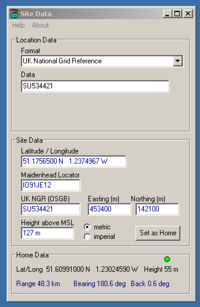
Mike Willis has a self-contained and accurate Windows utility, SiteData, for a variety of NGR, Locator, LatLng conversions near the bottom of his software page - http://www.mike-willis.com/software.html
Online - Convert an OS map 10 digit reference such as TG51401317 to Lat and Long here: http://www.movable-type.co.uk/scripts/latlong-gridref.html
